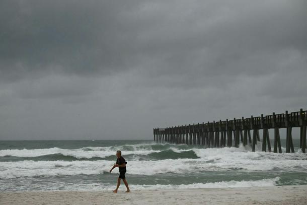
Waves grow more powerful in Pensacola Beach, Florida ahead of the arrival of Hurricane Isaias
Pensacola (United States) (AFP) - Hurricane Isaias lashed the US Gulf Coast with heavy rain and strong winds Friday night, as the Category 2 storm made landfall in northwestern Florida, the National Hurricane Center (NHC) said.
“Isaias makes landfall near Destin, Florida,” the NHC’s latest update said. “Life threatening storm surge impacting Gulf coast as dangerous hurricane conditions and flash flooding spread inland.”
Coastal communities saw mandatory evacuations and shuttered businesses as Isaias became the first hurricane of an Atlantic season that kicked off in June, held in check by a historic El Nino phenomenon that typically spurs more major storms in the Pacific.
In Pensacola, about 50 miles (80 kilometers) west of Destin in Florida, an AFP reporter witnessed howling winds rip the roofs from some homes and businesses, snapping tree branches as the power went out.
“Things are flying really fast, and I’ve never seen wind this fast before, so it’s intense, it’s scary,” Jonathan Ramos, a 40-year-old government employee, told AFP at his hotel in Pensacola, where the power went out.
“I don’t recommend people coming down here for fun to do this.”
More than 300,000 customers in Florida and 200,000 customers in Alabama were without power on Friday night, according to poweroutage.us.
Earlier Friday, caravans of repair trucks rolled through the cities of Pensacola and Navarre to staging areas in preparation for power outages, AFP reporters on the scene said. Water service to buildings was suspended.
The NHC said Isaias was packing maximum sustained winds of 105 miles per hour, with storm surges expected along the Gulf coast, from the mouth of the Mississippi River south of New Orleans to Florida’s Suwannee River.
Forecasters expected Isaias to slam into the western Florida panhandle at or near major hurricane strength before weakening over land.
Fueled by record-warm Gulf waters heated by climate change, it underwent rapid intensification, and is the first hurricane to strike the US mainland since Milton in 2024.
Florida Governor Ron DeSantis told a press briefing earlier Friday that “we’ve got a massive amount of supplies and personnel ready to respond once the storm hits.”
President Donald Trump cancelled his visit to Saturday’s college football game between the University of Georgia and the University of Alabama in Tuscaloosa, Alabama because of the hurricane.

Workers cordon off a gas pump with yellow tape at a gas station in Navarre, Florida as Hurricane Isaias approaches
Mandatory evacuation orders are in effect in several Florida counties, but impacts are expected across a swathe of the southeastern United States, with hurricane-force winds up to 100 miles inland.
Storm surge combined with the tide is expected to flood normally dry areas, with the NHC warning that water could reach as high as nine feet around the Alabama-Florida border. Heavy rainfall could trigger flash flooding and push rivers over their banks.
Two airports in northwestern Florida have suspended operations.
- Late arrival -
Isaias’s late arrival this season is largely due to an El Nino of historic strength.

This satellite handout image from the Cooperative Institute for Research in the Atmosphere at Colorado State University and the National Oceanic and Atmospheric Administration (CIRA/CSU and NOAA) shows Isaias developing in the Gulf of Mexico
El Nino, the warm phase of the El Nino-Southern Oscillation (ENSO), creates strong vertical wind shear over the Atlantic that tends to tear storms apart.
“We have been seeing basically nearly record strong shear throughout the Atlantic Basin this year, and that is consistent with what we’d expect to see with a strong El Nino event,” Michael Fischer, of University of Miami’s Rosenstiel School of Marine, Atmospheric, and Earth Science, told AFP.
In the Pacific, it has the opposite effect, weakening shear and allowing storms to grow. The Pacific has already produced several hurricanes this year, some of which hit maximum Category 5 strength.
“Sea surface temperatures in the Gulf of Mexico are in record territory because of fossil fuel-driven climate change,” Marc Alessi, a climate scientist with the Union of Concerned Scientists, told AFP. “Isaias was able to tap into all of that energy in the ocean to develop into a major hurricane.”
According to an analysis by nonprofit Climate Central, waters in the Gulf of Mexico are about 1.4C above the pre-industrial average, and Isaias “formed over waters that were 600 times more likely to be that temperature because of climate change,” Kristina Dahl, the group’s vice president for science, told AFP.
Storm surge will also be worsened because climate change has raised sea-levels by around 6.5 inches in this region, so the surge acts on a higher base, said Dahl. Heavy rainfall is also linked to warming since warmer oceans and atmosphere allow hurricanes to carry more moisture.
Isaias has disrupted oil and gas production in the Gulf of Mexico, with platforms and rigs evacuated.
As of Friday, about 71 percent of the region’s oil production had been temporarily halted, taking nearly 1.5 million barrels a day off the market, according to the Marine Minerals Administration (MMA). About 59 percent of gas production was also suspended.